Adaptive Fusion of Stochastic Information for Imaging Fractured Vadose Zones
A stochastic information fusion methodology is developed to assimilate electrical resistivity tomography, high-frequency ground penetrating radar, mid-range-frequency radar, pneumatic/gas tracer tomography, and hydraulic/tracer tomography to image fractures, characterize hydrogeophysical properties, and monitor natural processes in the vadose zone.
Hydraulic Tomography
 Hydraulic tomography (Yeh and Liu, 2000 and Liu, Yeh and Gardner, 2000) is a recently developed method for analyzing aquifers using several pumping and monitoring locations. The concept of hydraulic tomography is similar to that used in any tomographic investigation (ERT or CAT scans, etc.). Hydraulic tomography can be used to discern the anisotropy and heterogeneity inherent in the hydraulic parameters at a site, while 'textbook' pumping test solutions (i.e. Theis or Cooper-Jacob) assume homogeneity implicitly.
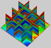
Electrical Resistivity Tomography (ERT)
 My research group is currently exploring the power of the ‘Stochastic Fusion’ (Yeh and Simunek, 2002) of different types of data in variably saturated geologic media utilizing a newly developed Sequential Successive Linear Estimator (SSLE) (Vargas-Guzman and Yeh, 2002 and Yeh et. al, 2002) approach.
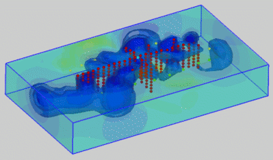
Joint ERT Inversion
My research group is currently focused on the modernization and improvement of variably saturated flow and transport modeling; we are exploring the use of the latest computational techniques (adaptive finite element mesh refinement and discrete event time domain methods) to maximize computational power with our available resources.
VSAFT2: Flow, Transport and Inversion
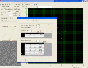 We are making available our powerful variably saturated two and three dimensional flow and transport models with user-friendly Graphical User Interfaces (GUIs). The GUI will allow a broader group of people to take advantage of the powerful forward and inverse modeling tools we have developed
Future Goals for Research
The ‘infusion’ of different types of data into the inversion process will be expanding beyond traditional geophysical modeling to include other data types, including natural stimuli tomography. Uncertainty can be reduced significantly when other, independent information is used to constrain the flow and transport system. Tracer and isotope studies can provide additional data as a ‘reality check’ on the results from the hydrologic and geophysical inversion process. In the future, we are intending to take advantage of stimuli that nature provides freely to us (gravitational tides, storm events, earthquakes and even lightning) that can be used to refine existing parameter inversions continuously, as data is received. This technology can dramatically increase the amount of data available for calibration, while relying less on costly invasive techniques like borehole drilling.